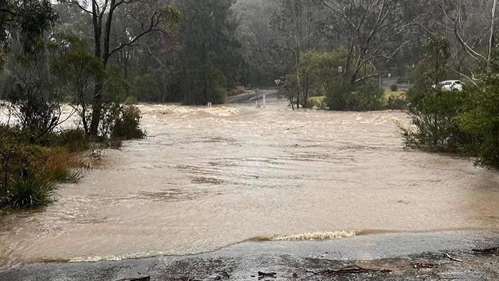
Chính quyền kêu gọi cư dân hủy bỏ đi holiday và tránh những vùng đang bị ngập lụt khi số lượng mưa tiếp tục đổ xuống NSW đặc biệt là thành phố Sydney.
Trong cuộc họp báo sáng nay, Thủ hiến Dominic Perrottet cho biết có 71 vùng trong NSW đã có lệnh phải di tản. Nước đang dâng cao vào trưa thứ Hai tại các Menangle, North Richmond, Windsor và Lower Portland trước khi đổ xuống các vùng Sackville và Wisemans Ferry.
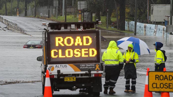
Ông Perrottet cũng đưa ra những lời cảnh báo nghiêm khắc đối với cư dân tại các vùng bị ảnh hưởng – phải tuyệt đối chấp hành lệnh của chính phủ và đặc biệt là tránh lái xe đến những con đường đang bị ngập lụt. Ông nói rằng cơ quan cấp cứu SES phải làm việc không ngừng nghỉ trong 3 ngày qua với 1593 cú gọi cấp cứu.
Mặc dầu NSW đã bị mưa liên tục trong 3 ngày qua nhưng chính quyền cho biết tiểu bang vẫn còn đặt trong tình trạnh báo động bởi vì số lượng mưa vẫn không giảm trong vài ngày tới.

Lệnh di tản vì lũ lụt
Cơ Quan Cấp Cứu (SES) vừa đưa ra những lệnh di tản khỏi những vùng đang bị cho là nguy hiểm đến tính mạng và lệnh di tản có hiệu lực từ 9 giờ sáng thứ Hai 4/7/2022.
Người dân sống tại các vùng dưới đây phải di tản theo giờ đi kèm.
– Parts of Cattai trễ nhất là 2 giờ trưa thứ Hai.
– Parts of Sackville North trễ nhất là 12.30 trưa thứ Hai.
– Lower Hawkesbury area downstream of Wisemans Ferry
– Parts of Richards
– Parts of Londonderry
– Parts of Riverstone
– Parts of Pitt Town (southern end) and Pitt Town Bottoms
– Parts of Agnes Banks
– South Maroota (west)
– Parts of Cattai (Riverside Caravan Park)
– Parts of Lower Portland (north east)
– Parts of Penrith – Peach Tree Creek South
– Central Part of Yarramundi
– Parts of Emu Heights (north)
– Parts of Emu Plains (north east)
– Sackville (north and north east, Tizanna Rd, Madeline Pl)
– Parts of Sackville North (Mud Hill Rd, Pages Wharf Rd)
– Lower Portland (east and north, eastern side of Hawkesbury River)
– Parts of Leets Vale
– Cumberland Reach
– Parts of Oakville (Saunders Rd)
– Windsor (northern part)
– Parts of Ebenezer (Tizanna Rd, Hendrens Rd, Ebenezers Wharf Rd, Coromandel Road, Port Erringhi Road)
– Low-lying part of Freemans Reach
– North Richmond (parts of Terrace Road)
– Cornwallis and eastern part of Richmond Lowlands
– Western part of Richmond Lowlands
– North of Bligh Park
– Gronos Point
– Plough and Harrow Dam
– Parts of Pleasure Point
– Bents Basin area
– Parts of Wallacia
– Parts of Camden (Ellisa la, Christopher Ave, Edward St, Sheathers Lane, Chellaston and Cawdor, Cut Hill and Cobbity)
– Low lying parts of Woronora
– Parts of Georges Hall
– Parts of Lansvale
– Parts of Moorebank
– Part of Chipping Norton
– Parts of Warwick Farm
Những trung dân di tản
Cơ quan SES đã thiết lập nhiều trung tâm để tạm cư những cư dân tại những vùng đang bị ảnh hưởng trên toàn Sydney:
– Canley Vale – Cabra-Vale Diggers Club, 1 Bartley Street, Canley Vale
– Narellan – Family & Community Centre, Queen Street, Narellan
– Gymea – Gymea Tradies Club, Kingsway Gymea
– Richmond – Richmond Club, Market Street, Richmond
– North Richmond – North Richmond Community Centre, William Street, North Richmond
– Castle Hill RSL – 77 Castle Street, Castle Hill
Muốn biết thêm chi tiết xin vào trang web của SES: SES NSW website.